Seerab proudly showcase its innovative and unique projects
-
Real Estate GIS Maps – PropTech
-
Visualization of Honour Crimes in Punjab Pakistan – Analytics & Data Visualization
-
Umrah Hajj GIS Maps – TourismTech
-
DigiFarm – AgriTech
1-Real Estate GIS Maps – PropTech:
Seerab Maps – Innovative Geospatial PropTech Solution for Real Estate
First time in Pakistan, Seerab produced online real estate property GIS maps using latest geospatial technologies and tools.
Since 2016, Empowering realtor community with location intelligent maps. Pakistan’s Major cities major Housing Society, Industrial Estate, Land Revenue, Patwar, Roads, Avenue, Highways, Motorways & City master plan maps are available. Seerab Maps helps user visualize, analyze, identify, locate and verify exact location of housing societies & plots while sitting anywhere in world. Seerab Maps facilitate big number of inland and overseas Pakistanis.
Real estate maps overlaid on google maps, google satellite image and terrain. By combining all these map layers you can locate, identify and analyze housing society & plots locations. Real estate map has transparency slider to make it transparent according to need while overlaid on google maps, google satellite image and terrain.
The Map layer overlaid with real estate property maps provides you with information about streets, road network, parks and facilities in the area. You can compare and analyze existing and future infrastructure of the area too which help you to make your decision.
The Satellite layer provides you with a bird’s-eye view of the area using satellite imaging. This layer is useful for everything from finding out open land, built up area, roads and which of your neighbors has built their homes.
The Terrain layer will turn on a topographical overlay to show changes in elevation. Darker areas with lines that are close together represent steep inclines. Hint: Use this in conjunction with the real estate property map to identify depressions and high & low locations.
This project will help all real estate stakeholders not to get the whole picture of area and housing societies but also help a lay man by saving their time searching for suitable locations. By sitting in front of your computer or holding cell phone, a person will able to mark his ideal location and locate it on ground to check it physically. In future we will add more features in it to make it complete real estate platform.
Seerab Maps is Pakistan’s most prestigious P@sha ICT Awards 2018 winner as “Best innovation in Real Estate” and finalists of UberPitch 2018 as well.
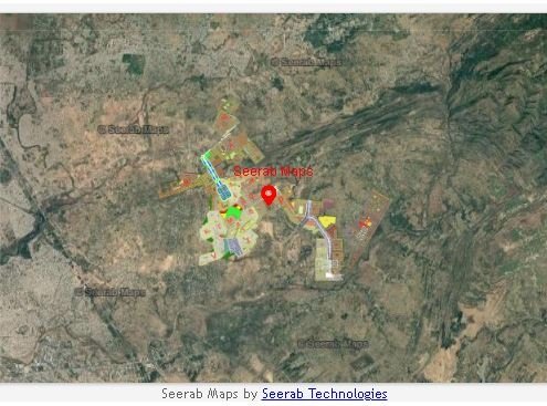 https://www.seerab.com/wp-content/uploads/2017/04/gulberg-islamabad-map.jpg
367
975
Author
https://seerab.com/wp-content/uploads/2017/04/Seerab-Logo-Landscape-Website-300x113.png
Author2017-04-17 16:08:172025-09-14 21:34:36Gulberg Islamabad Map
https://www.seerab.com/wp-content/uploads/2017/04/gulberg-islamabad-map.jpg
367
975
Author
https://seerab.com/wp-content/uploads/2017/04/Seerab-Logo-Landscape-Website-300x113.png
Author2017-04-17 16:08:172025-09-14 21:34:36Gulberg Islamabad Map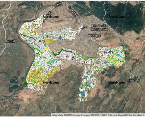 https://www.seerab.com/wp-content/uploads/2018/03/Bahria-Town-Phase-8-Map.jpg
455
1213
Author
https://seerab.com/wp-content/uploads/2017/04/Seerab-Logo-Landscape-Website-300x113.png
Author2017-03-16 17:34:162022-10-02 22:54:00Bahria Town Phase 8 Map Rawalpindi
https://www.seerab.com/wp-content/uploads/2018/03/Bahria-Town-Phase-8-Map.jpg
455
1213
Author
https://seerab.com/wp-content/uploads/2017/04/Seerab-Logo-Landscape-Website-300x113.png
Author2017-03-16 17:34:162022-10-02 22:54:00Bahria Town Phase 8 Map Rawalpindi2-Visualization of Honour Crimes in Punjab Pakistan:
Our second major project is about Data Analytic, Geo Analytic and Interactive Data Visualization. The data used for this project was collected from Punjab Police official web site. The data provided there was in form of table, every piece of information provided was hard to understand and time taking. Keeping track of honor killing rise/fall extremely difficult. At Seerab, using analytic & visualization we used the data in way that it tells its story itself. Interactive visualization make clear whole picture that when, how, which areas are most affected and in which year the honor killing rate was high, just selecting area, year and district options provided in the visuals.
This project aims is to provide easy to understand visualization to explore & analyses and provide insights & trends in data to identify locations of low & high honour crimes so concern organization can work effectively in those area to identify root causes and to take preventive measure.
Data Analytic, Geo Analytic and Interactive Data Visualization are very power tools to tell the whole story.
Click to Explore the below interactive visualization.
Interactive Data Visualization of Honour Crimes in Punjab Pakistan
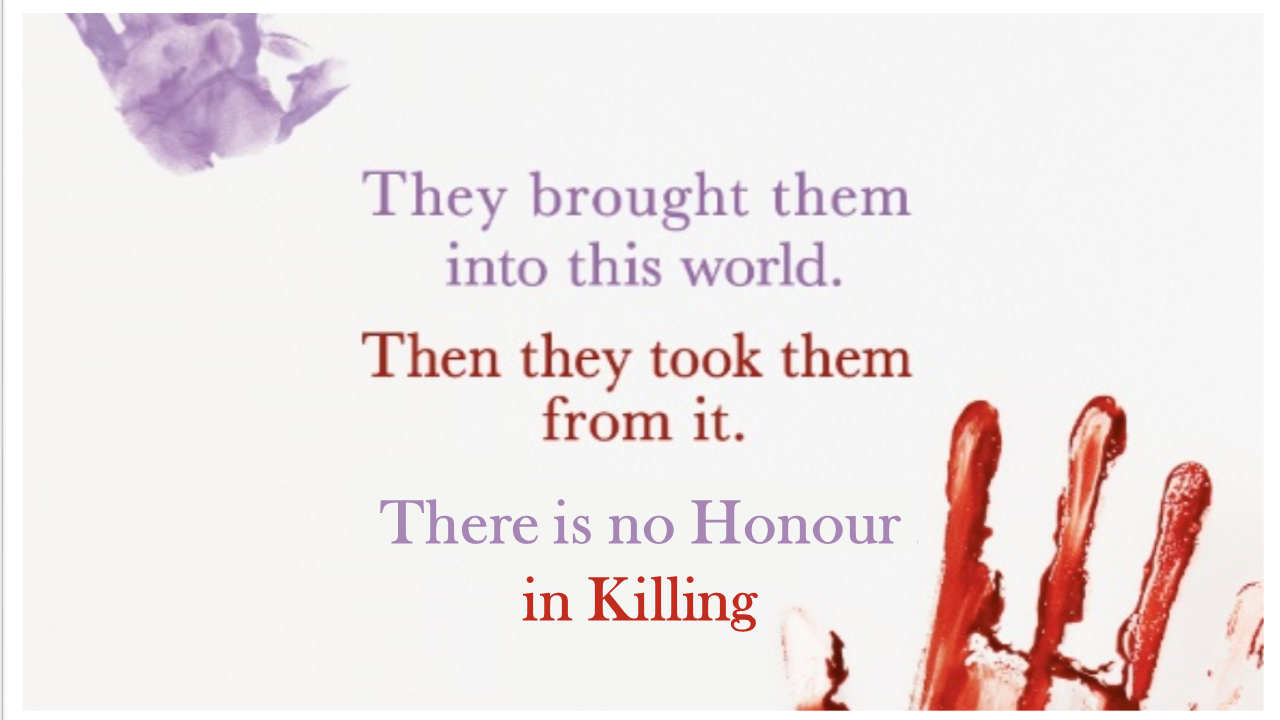 https://www.seerab.com/wp-content/uploads/2017/04/Punjab-Honour-Killing-2011-2016-Title-Image.png
720
1280
Author
https://seerab.com/wp-content/uploads/2017/04/Seerab-Logo-Landscape-Website-300x113.png
Author2017-04-07 20:18:532018-02-23 10:19:31Visualization of Honour Crimes in Punjab Pakistan
https://www.seerab.com/wp-content/uploads/2017/04/Punjab-Honour-Killing-2011-2016-Title-Image.png
720
1280
Author
https://seerab.com/wp-content/uploads/2017/04/Seerab-Logo-Landscape-Website-300x113.png
Author2017-04-07 20:18:532018-02-23 10:19:31Visualization of Honour Crimes in Punjab Pakistan3-Umrah Hajj Maps – TourismTech:
Seerab Umrah Hajj Maps – Geo intelligence for Hajj
Masjid Al-Haram, Al Madinah Al Munawwarah, Aziziyah, Mina & Arafat Maps
With Umrah Maps Find and Locate Facilities, Gates & Hotels at Masjid Al-Haram, Aziziyah, Al-Masjid An-Nabawi & Al Madinah Al Munawwarah.
Umrah Maps show Facilities, Gates & Hotels locations on map and provide tools to search, locate, navigate to and share it easily
With Hajj Maps Find and Locate Makatibs & Camps at Mina & Arafat
Hajj Maps show Makatibs & Camps locations on map and provide tools to search, locate, navigate to and share Makatibs & Camps easily
A very unique project used geospatial technologies to help Pilgrims of Hajj. The Hajj is the largest annual gathering of people in the world. Seerab Umrah Hajj Maps – A Nobel service by Seerab Technologies to facilitate and empower haji’s (pilgrim), Scouts, anyone with mobile phone with location intelligence. Seerab Umrah Hajj Map provides Masjid Al-Haram, Al Madinah Al Munawwarah, Aziziyah, Mina & Arafat GIS Maps, easy to use. Pilgrim and Scouts may search, sort, find, locate, share, bookmark his/her location, understand surroundings, bookmark facilities and many other features to make Hajj a memorable experience. Seerab Umrah Hajj Maps is Pakistan’s most prestigious P@sha ICT Awards 2019 winner as “Best Community Service”.
4-Seerab AgriTech – DigiFarm:
Innovated technologies for automatically detecting the world’s highest accuracy field boundaries and seeded acres and super resolved upscale 10X earth observation (EO) sentinel-2 satellite data using AI & Machine Learning. Ready to use innovative earth observation Satellite Imagery & AgriTech solution.
Satellite images are one of the most powerful and important tools we have for monitoring the earth. Sentinel-2 Super Resolution 1 meter Satellite Imagery with 10 Spectral Band and 5 days Temporal Resolution (none other EO provider has all these features) which is good for e.g. base maps, monitoring & agriculture etc.
Providing Boundary Delineation (world’s most accurate field boundaries) & Seeded Acres, Productivity zones, Field Sustainability Index, Crop Detection, Sentenel-2 Time Series using AI & Machine Learning for agriculture.