Housing Society Maps – Karachi
Master Plan Housing Society Maps | Real Estate Maps
Discover detailed housing societies, industrial estates, patwar revenue & cadastral, city & unban master plans, major roads avenues highways motorways & infrastructure, historical & geological maps for Karachi, including master plans, plot layouts & layout plan (LoPs), road networks, and sectors layout & boundaries. Whether you’re a real estate professionals, investors, real estate developer, urban planner, government bodies or buyer, Seerab Maps offer essential insights into approved and developing projects across the city. Updated regularly, each map highlights key zones, accessibility routes, and land-use divisions to support better decision-making.
🔍 Seerab Maps – Pakistan’s Leading Geospatial PropTech Solution for Real Estate, Urban Planning & Development Monitoring
💼 Why Seerab Maps?
✔ Trusted since 2016
✔ P@SHA ICT Award Winner 2018 – Best Innovation in Real Estate
✔ Finalist – UberPitch 2018
✔ Real-time online & on-site plot verification
✔ Reliable geospatial insights for urban development, planning, and investment security
💡 Don’t fall for deceptive property marketing. With Seerab Maps, know exactly where your plot lies, its surroundings, and ongoing development—before you invest.
Karachi is a growing hub of modern housing societies and infrastructure. Seerab Maps showcase approved layouts, development status, and planning visuals for both private and public schemes across the district.
 Seerab Maps
https://www.seerab.com/wp-content/uploads/2021/10/precinct-26a-bahria-town-karachi-map.jpg
365
972
Author
https://seerab.com/wp-content/uploads/2017/04/Seerab-Logo-Landscape-Website-300x113.png
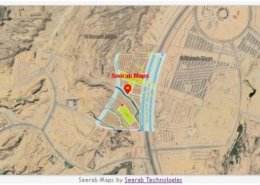
Author2021-10-07 23:51:202022-11-09 20:26:19Precinct 26A Bahria Town Karachi Map
Seerab Maps
https://www.seerab.com/wp-content/uploads/2021/10/precinct-26a-bahria-town-karachi-map.jpg
365
972
Author
https://seerab.com/wp-content/uploads/2017/04/Seerab-Logo-Landscape-Website-300x113.png
Author2021-10-07 23:51:202022-11-09 20:26:19Precinct 26A Bahria Town Karachi Map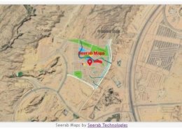 https://www.seerab.com/wp-content/uploads/2021/10/precinct-25a-bahria-town-karachi-map.jpg
368
974
Author
https://seerab.com/wp-content/uploads/2017/04/Seerab-Logo-Landscape-Website-300x113.png
Author2021-10-07 23:47:522022-11-09 20:28:08Precinct 25A Bahria Town Karachi Map
https://www.seerab.com/wp-content/uploads/2021/10/precinct-25a-bahria-town-karachi-map.jpg
368
974
Author
https://seerab.com/wp-content/uploads/2017/04/Seerab-Logo-Landscape-Website-300x113.png
Author2021-10-07 23:47:522022-11-09 20:28:08Precinct 25A Bahria Town Karachi Map https://www.seerab.com/wp-content/uploads/2021/07/dha-city-karachi-central-business-district-market.jpg
366
972
Author
https://seerab.com/wp-content/uploads/2017/04/Seerab-Logo-Landscape-Website-300x113.png
Author2021-07-28 17:51:212022-11-09 23:05:37DHA City Karachi Central Business District Market Map
https://www.seerab.com/wp-content/uploads/2021/07/dha-city-karachi-central-business-district-market.jpg
366
972
Author
https://seerab.com/wp-content/uploads/2017/04/Seerab-Logo-Landscape-Website-300x113.png
Author2021-07-28 17:51:212022-11-09 23:05:37DHA City Karachi Central Business District Market Map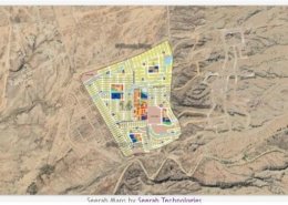 https://www.seerab.com/wp-content/uploads/2021/05/dha-city-karachi-sector-14-map.jpg
366
972
Author
https://seerab.com/wp-content/uploads/2017/04/Seerab-Logo-Landscape-Website-300x113.png
Author2021-05-11 01:47:262022-05-29 21:54:32DHA City Karachi Sector 14 Map
https://www.seerab.com/wp-content/uploads/2021/05/dha-city-karachi-sector-14-map.jpg
366
972
Author
https://seerab.com/wp-content/uploads/2017/04/Seerab-Logo-Landscape-Website-300x113.png
Author2021-05-11 01:47:262022-05-29 21:54:32DHA City Karachi Sector 14 Map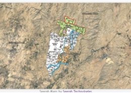 https://www.seerab.com/wp-content/uploads/2021/04/bahria-town-karachi-map-location-map.jpg
365
972
Author
https://seerab.com/wp-content/uploads/2017/04/Seerab-Logo-Landscape-Website-300x113.png
Author2021-04-13 16:00:382022-06-01 14:11:07Bahria Town Karachi Map – Location Map
https://www.seerab.com/wp-content/uploads/2021/04/bahria-town-karachi-map-location-map.jpg
365
972
Author
https://seerab.com/wp-content/uploads/2017/04/Seerab-Logo-Landscape-Website-300x113.png
Author2021-04-13 16:00:382022-06-01 14:11:07Bahria Town Karachi Map – Location Map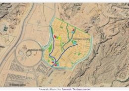 https://www.seerab.com/wp-content/uploads/2021/04/precinct-33-bahria-town-karachi-map.jpg
365
973
Author
https://seerab.com/wp-content/uploads/2017/04/Seerab-Logo-Landscape-Website-300x113.png
Author2021-04-11 16:00:212022-06-01 14:10:44Precinct 33 Bahria Town Karachi Map
https://www.seerab.com/wp-content/uploads/2021/04/precinct-33-bahria-town-karachi-map.jpg
365
973
Author
https://seerab.com/wp-content/uploads/2017/04/Seerab-Logo-Landscape-Website-300x113.png
Author2021-04-11 16:00:212022-06-01 14:10:44Precinct 33 Bahria Town Karachi Map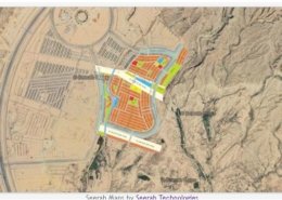 https://www.seerab.com/wp-content/uploads/2021/04/precinct-32-bahria-town-karachi-map.jpg
365
970
Author
https://seerab.com/wp-content/uploads/2017/04/Seerab-Logo-Landscape-Website-300x113.png
Author2021-04-11 15:00:362022-06-01 14:10:20Precinct 32 Bahria Town Karachi Map
https://www.seerab.com/wp-content/uploads/2021/04/precinct-32-bahria-town-karachi-map.jpg
365
970
Author
https://seerab.com/wp-content/uploads/2017/04/Seerab-Logo-Landscape-Website-300x113.png
Author2021-04-11 15:00:362022-06-01 14:10:20Precinct 32 Bahria Town Karachi Map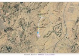 https://www.seerab.com/wp-content/uploads/2021/04/precinct-21-bahria-town-karachi-map.jpg
369
973
Author
https://seerab.com/wp-content/uploads/2017/04/Seerab-Logo-Landscape-Website-300x113.png
Author2021-04-10 16:00:452022-06-01 14:09:57Precinct 21 Bahria Town Karachi Map
https://www.seerab.com/wp-content/uploads/2021/04/precinct-21-bahria-town-karachi-map.jpg
369
973
Author
https://seerab.com/wp-content/uploads/2017/04/Seerab-Logo-Landscape-Website-300x113.png
Author2021-04-10 16:00:452022-06-01 14:09:57Precinct 21 Bahria Town Karachi Map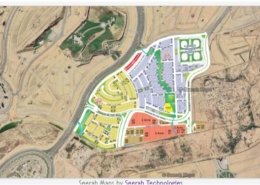 https://www.seerab.com/wp-content/uploads/2021/04/precinct-17-bahria-town-karachi-map.jpg
364
973
Author
https://seerab.com/wp-content/uploads/2017/04/Seerab-Logo-Landscape-Website-300x113.png
Author2021-04-10 15:00:552022-06-01 14:09:36Precinct 17 Bahria Town Karachi Map
https://www.seerab.com/wp-content/uploads/2021/04/precinct-17-bahria-town-karachi-map.jpg
364
973
Author
https://seerab.com/wp-content/uploads/2017/04/Seerab-Logo-Landscape-Website-300x113.png
Author2021-04-10 15:00:552022-06-01 14:09:36Precinct 17 Bahria Town Karachi Map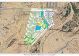 https://www.seerab.com/wp-content/uploads/2021/04/precinct-15-b-bahria-town-karachi-map.jpg
367
973
Author
https://seerab.com/wp-content/uploads/2017/04/Seerab-Logo-Landscape-Website-300x113.png
Author2021-04-09 16:00:302022-06-01 14:09:17Precinct 15 B Bahria Town Karachi Map
https://www.seerab.com/wp-content/uploads/2021/04/precinct-15-b-bahria-town-karachi-map.jpg
367
973
Author
https://seerab.com/wp-content/uploads/2017/04/Seerab-Logo-Landscape-Website-300x113.png
Author2021-04-09 16:00:302022-06-01 14:09:17Precinct 15 B Bahria Town Karachi Map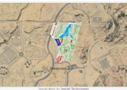 https://www.seerab.com/wp-content/uploads/2021/04/precinct-15-bahria-town-karachi-map.jpg
364
974
Author
https://seerab.com/wp-content/uploads/2017/04/Seerab-Logo-Landscape-Website-300x113.png
Author2021-04-09 15:00:352022-06-01 14:08:53Precinct 15 Bahria Town Karachi Map
https://www.seerab.com/wp-content/uploads/2021/04/precinct-15-bahria-town-karachi-map.jpg
364
974
Author
https://seerab.com/wp-content/uploads/2017/04/Seerab-Logo-Landscape-Website-300x113.png
Author2021-04-09 15:00:352022-06-01 14:08:53Precinct 15 Bahria Town Karachi Map https://www.seerab.com/wp-content/uploads/2021/02/precinct-31-bahria-town-karachi-map.jpg
365
970
Author
https://seerab.com/wp-content/uploads/2017/04/Seerab-Logo-Landscape-Website-300x113.png
Author2021-02-19 01:44:232022-06-01 14:08:16Precinct 31 Bahria Town Karachi Map
https://www.seerab.com/wp-content/uploads/2021/02/precinct-31-bahria-town-karachi-map.jpg
365
970
Author
https://seerab.com/wp-content/uploads/2017/04/Seerab-Logo-Landscape-Website-300x113.png
Author2021-02-19 01:44:232022-06-01 14:08:16Precinct 31 Bahria Town Karachi Map