Housing Society Maps – Multan
Master Plan Housing Society Maps | Real Estate Maps
Discover detailed housing societies, industrial estates, patwar revenue & cadastral, city & unban master plans, major roads avenues highways motorways & infrastructure, historical & geological maps for Multan, including master plans, plot layouts & layout plan (LoPs), road networks, and sectors layout & boundaries. Whether you’re a real estate professionals, investors, real estate developer, urban planner, government bodies or buyer, Seerab Maps offer essential insights into approved and developing projects across the city. Updated regularly, each map highlights key zones, accessibility routes, and land-use divisions to support better decision-making.
🔍 Seerab Maps – Pakistan’s Leading Geospatial PropTech Solution for Real Estate, Urban Planning & Development Monitoring
💼 Why Seerab Maps?
✔ Trusted since 2016
✔ P@SHA ICT Award Winner 2018 – Best Innovation in Real Estate
✔ Finalist – UberPitch 2018
✔ Real-time online & on-site plot verification
✔ Reliable geospatial insights for urban development, planning, and investment security
💡 Don’t fall for deceptive property marketing. With Seerab Maps, know exactly where your plot lies, its surroundings, and ongoing development—before you invest.
Multan is a growing hub of modern housing societies and infrastructure. Seerab Maps showcase approved layouts, development status, and planning visuals for both private and public schemes across the district.
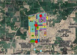 https://www.seerab.com/wp-content/uploads/2020/07/royal-orchard-multan-map.jpg
427
1192
Author
https://seerab.com/wp-content/uploads/2017/04/Seerab-Logo-Landscape-Website-300x113.png
Author2020-07-01 13:10:492022-05-31 17:03:03Royal Orchard Multan Map
https://www.seerab.com/wp-content/uploads/2020/07/royal-orchard-multan-map.jpg
427
1192
Author
https://seerab.com/wp-content/uploads/2017/04/Seerab-Logo-Landscape-Website-300x113.png
Author2020-07-01 13:10:492022-05-31 17:03:03Royal Orchard Multan Map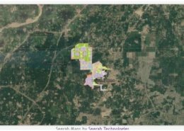 https://www.seerab.com/wp-content/uploads/2020/06/citi-housing-multan-map.jpg
366
973
Author
https://seerab.com/wp-content/uploads/2017/04/Seerab-Logo-Landscape-Website-300x113.png
Author2020-06-25 00:00:472022-05-31 17:02:44Citi Housing Multan Map
https://www.seerab.com/wp-content/uploads/2020/06/citi-housing-multan-map.jpg
366
973
Author
https://seerab.com/wp-content/uploads/2017/04/Seerab-Logo-Landscape-Website-300x113.png
Author2020-06-25 00:00:472022-05-31 17:02:44Citi Housing Multan Map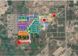 https://www.seerab.com/wp-content/uploads/2020/04/dream-gardens-multan-map.jpg
427
1192
Author
https://seerab.com/wp-content/uploads/2017/04/Seerab-Logo-Landscape-Website-300x113.png
Author2020-04-24 02:22:362022-05-31 17:02:24Dream Gardens Multan Map
https://www.seerab.com/wp-content/uploads/2020/04/dream-gardens-multan-map.jpg
427
1192
Author
https://seerab.com/wp-content/uploads/2017/04/Seerab-Logo-Landscape-Website-300x113.png
Author2020-04-24 02:22:362022-05-31 17:02:24Dream Gardens Multan Map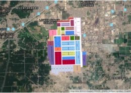 https://www.seerab.com/wp-content/uploads/2020/01/multan-industrial-estate.jpg
454
1214
Author
https://seerab.com/wp-content/uploads/2017/04/Seerab-Logo-Landscape-Website-300x113.png
Author2020-01-16 21:12:312022-05-29 23:34:46Multan Industrial Estate Map
https://www.seerab.com/wp-content/uploads/2020/01/multan-industrial-estate.jpg
454
1214
Author
https://seerab.com/wp-content/uploads/2017/04/Seerab-Logo-Landscape-Website-300x113.png
Author2020-01-16 21:12:312022-05-29 23:34:46Multan Industrial Estate Map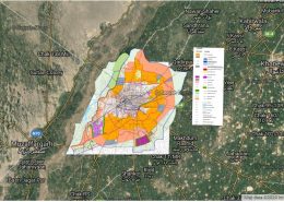 https://www.seerab.com/wp-content/uploads/2020/01/multan-master-plan-map.jpg
454
1215
Author
https://seerab.com/wp-content/uploads/2017/04/Seerab-Logo-Landscape-Website-300x113.png
Author2020-01-10 01:26:412022-05-31 17:02:00Multan Master Plan Map
https://www.seerab.com/wp-content/uploads/2020/01/multan-master-plan-map.jpg
454
1215
Author
https://seerab.com/wp-content/uploads/2017/04/Seerab-Logo-Landscape-Website-300x113.png
Author2020-01-10 01:26:412022-05-31 17:02:00Multan Master Plan Map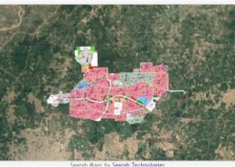 https://www.seerab.com/wp-content/uploads/2019/08/dha-multan-map.jpg
362
971
Author
https://seerab.com/wp-content/uploads/2017/04/Seerab-Logo-Landscape-Website-300x113.png
Author2019-08-31 21:13:342022-06-01 16:32:26Dha Multan Map
https://www.seerab.com/wp-content/uploads/2019/08/dha-multan-map.jpg
362
971
Author
https://seerab.com/wp-content/uploads/2017/04/Seerab-Logo-Landscape-Website-300x113.png
Author2019-08-31 21:13:342022-06-01 16:32:26Dha Multan Map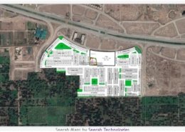 https://www.seerab.com/wp-content/uploads/2019/06/dha-multan-villas-map.jpg
365
971
Author
https://seerab.com/wp-content/uploads/2017/04/Seerab-Logo-Landscape-Website-300x113.png
Author2019-06-30 16:03:022022-06-01 17:18:55Dha Multan Villas Map
https://www.seerab.com/wp-content/uploads/2019/06/dha-multan-villas-map.jpg
365
971
Author
https://seerab.com/wp-content/uploads/2017/04/Seerab-Logo-Landscape-Website-300x113.png
Author2019-06-30 16:03:022022-06-01 17:18:55Dha Multan Villas Map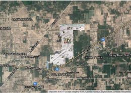 https://www.seerab.com/wp-content/uploads/2018/05/Punjab-Government-Servants-Housing-Foundation-PGSHF-Multan.jpg
567
1517
Author
https://seerab.com/wp-content/uploads/2017/04/Seerab-Logo-Landscape-Website-300x113.png
Author2017-11-27 03:47:562022-05-31 17:00:30PGSHF Multan Map
https://www.seerab.com/wp-content/uploads/2018/05/Punjab-Government-Servants-Housing-Foundation-PGSHF-Multan.jpg
567
1517
Author
https://seerab.com/wp-content/uploads/2017/04/Seerab-Logo-Landscape-Website-300x113.png
Author2017-11-27 03:47:562022-05-31 17:00:30PGSHF Multan Map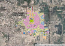 https://www.seerab.com/wp-content/uploads/2018/05/Wapda-Town-Phase-II-Multan.jpg
569
1516
Author
https://seerab.com/wp-content/uploads/2017/04/Seerab-Logo-Landscape-Website-300x113.png
Author2017-11-27 03:46:382022-05-31 17:00:06Wapda Town Multan Phase 2 Map
https://www.seerab.com/wp-content/uploads/2018/05/Wapda-Town-Phase-II-Multan.jpg
569
1516
Author
https://seerab.com/wp-content/uploads/2017/04/Seerab-Logo-Landscape-Website-300x113.png
Author2017-11-27 03:46:382022-05-31 17:00:06Wapda Town Multan Phase 2 Map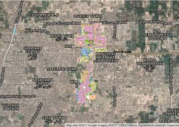 https://www.seerab.com/wp-content/uploads/2018/05/Wapda-Town-Phase-I-Multan.jpg
564
1516
Author
https://seerab.com/wp-content/uploads/2017/04/Seerab-Logo-Landscape-Website-300x113.png
Author2017-11-27 03:45:492022-05-31 17:07:49Wapda Town Multan Phase 1 Map
https://www.seerab.com/wp-content/uploads/2018/05/Wapda-Town-Phase-I-Multan.jpg
564
1516
Author
https://seerab.com/wp-content/uploads/2017/04/Seerab-Logo-Landscape-Website-300x113.png
Author2017-11-27 03:45:492022-05-31 17:07:49Wapda Town Multan Phase 1 Map