Housing Society Maps – Rawalpindi
Master Plan Housing Society Maps | Real Estate Maps
Discover detailed housing societies, industrial estates, patwar revenue & cadastral, city & unban master plans, major roads avenues highways motorways & infrastructure, historical & geological maps for Rawalpindi, including master plans, plot layouts & layout plan (LoPs), road networks, and sectors layout & boundaries. Whether you’re a real estate professionals, investors, real estate developer, urban planner, government bodies or buyer, Seerab Maps offer essential insights into approved and developing projects across the city. Updated regularly, each map highlights key zones, accessibility routes, and land-use divisions to support better decision-making.
🔍 Seerab Maps – Pakistan’s Leading Geospatial PropTech Solution for Real Estate, Urban Planning & Development Monitoring
💼 Why Seerab Maps?
✔ Trusted since 2016
✔ P@SHA ICT Award Winner 2018 – Best Innovation in Real Estate
✔ Finalist – UberPitch 2018
✔ Real-time online & on-site plot verification
✔ Reliable geospatial insights for urban development, planning, and investment security
💡 Don’t fall for deceptive property marketing. With Seerab Maps, know exactly where your plot lies, its surroundings, and ongoing development—before you invest.
Rawalpindi is a growing hub of modern housing societies and infrastructure. Seerab Maps showcase approved layouts, development status, and planning visuals for both private and public schemes across the district.
 Seerab Maps
https://www.seerab.com/wp-content/uploads/2022/11/dha-valley-bougainvillea-islamabad-rawalpindi-map.webp
366
972
Author
https://seerab.com/wp-content/uploads/2017/04/Seerab-Logo-Landscape-Website-300x113.png
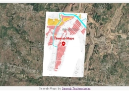
Author2022-11-18 23:00:222022-11-18 23:00:22Dha Valley Bougainvillea Islamabad Rawalpindi Map
Seerab Maps
https://www.seerab.com/wp-content/uploads/2022/11/dha-valley-bougainvillea-islamabad-rawalpindi-map.webp
366
972
Author
https://seerab.com/wp-content/uploads/2017/04/Seerab-Logo-Landscape-Website-300x113.png
Author2022-11-18 23:00:222022-11-18 23:00:22Dha Valley Bougainvillea Islamabad Rawalpindi Map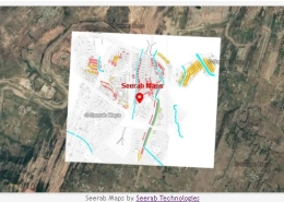 Seerab Maps
https://www.seerab.com/wp-content/uploads/2022/11/dha-valley-bluebell-islamabad-rawalpindi-map.webp
362
970
Author
https://seerab.com/wp-content/uploads/2017/04/Seerab-Logo-Landscape-Website-300x113.png
Author2022-11-18 22:27:372022-11-18 22:29:51Dha Valley Bluebell Islamabad Rawalpindi Map
Seerab Maps
https://www.seerab.com/wp-content/uploads/2022/11/dha-valley-bluebell-islamabad-rawalpindi-map.webp
362
970
Author
https://seerab.com/wp-content/uploads/2017/04/Seerab-Logo-Landscape-Website-300x113.png
Author2022-11-18 22:27:372022-11-18 22:29:51Dha Valley Bluebell Islamabad Rawalpindi Map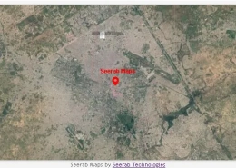 Seerab Maps
https://www.seerab.com/wp-content/uploads/2022/10/Lai-Expressway-Map.webp
361
972
Author
https://seerab.com/wp-content/uploads/2017/04/Seerab-Logo-Landscape-Website-300x113.png
Author2022-10-30 19:30:002022-10-30 19:30:00Lai Expressway Map
Seerab Maps
https://www.seerab.com/wp-content/uploads/2022/10/Lai-Expressway-Map.webp
361
972
Author
https://seerab.com/wp-content/uploads/2017/04/Seerab-Logo-Landscape-Website-300x113.png
Author2022-10-30 19:30:002022-10-30 19:30:00Lai Expressway Map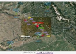 https://www.seerab.com/wp-content/uploads/2022/10/kharian-rawalpindi-motorway-route-map.jpg
364
972
Author
https://seerab.com/wp-content/uploads/2017/04/Seerab-Logo-Landscape-Website-300x113.png
Author2022-10-21 21:47:072022-11-06 23:43:19Kharian Rawalpindi Motorway Route Map
https://www.seerab.com/wp-content/uploads/2022/10/kharian-rawalpindi-motorway-route-map.jpg
364
972
Author
https://seerab.com/wp-content/uploads/2017/04/Seerab-Logo-Landscape-Website-300x113.png
Author2022-10-21 21:47:072022-11-06 23:43:19Kharian Rawalpindi Motorway Route Map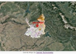 https://www.seerab.com/wp-content/uploads/2022/08/punjab-land-revenue-rawalpindi-district-map.jpg
364
972
Author
https://seerab.com/wp-content/uploads/2017/04/Seerab-Logo-Landscape-Website-300x113.png
Author2022-08-12 15:28:372022-08-12 15:28:37Punjab Land Revenue Rawalpindi District Map
https://www.seerab.com/wp-content/uploads/2022/08/punjab-land-revenue-rawalpindi-district-map.jpg
364
972
Author
https://seerab.com/wp-content/uploads/2017/04/Seerab-Logo-Landscape-Website-300x113.png
Author2022-08-12 15:28:372022-08-12 15:28:37Punjab Land Revenue Rawalpindi District Map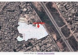 https://www.seerab.com/wp-content/uploads/2022/05/shifa-cooperative-housing-society-rawalpindi-map.jpg
366
974
Author
https://seerab.com/wp-content/uploads/2017/04/Seerab-Logo-Landscape-Website-300x113.png
Author2022-05-27 23:55:512022-11-09 16:09:09Shifa Cooperative Housing Society Rawalpindi Map
https://www.seerab.com/wp-content/uploads/2022/05/shifa-cooperative-housing-society-rawalpindi-map.jpg
366
974
Author
https://seerab.com/wp-content/uploads/2017/04/Seerab-Logo-Landscape-Website-300x113.png
Author2022-05-27 23:55:512022-11-09 16:09:09Shifa Cooperative Housing Society Rawalpindi Map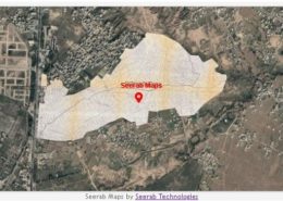 https://www.seerab.com/wp-content/uploads/2022/05/atomic-energy-housing-society-rawalpindi-map.jpg
364
973
Author
https://seerab.com/wp-content/uploads/2017/04/Seerab-Logo-Landscape-Website-300x113.png
Author2022-05-27 20:48:272022-11-09 16:12:47Atomic Energy Housing Society Rawalpindi Map
https://www.seerab.com/wp-content/uploads/2022/05/atomic-energy-housing-society-rawalpindi-map.jpg
364
973
Author
https://seerab.com/wp-content/uploads/2017/04/Seerab-Logo-Landscape-Website-300x113.png
Author2022-05-27 20:48:272022-11-09 16:12:47Atomic Energy Housing Society Rawalpindi Map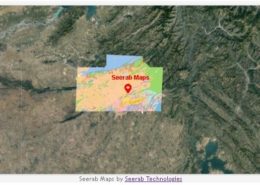 https://www.seerab.com/wp-content/uploads/2022/05/islamabad-rawalpindi-geological-map.jpg
367
974
Author
https://seerab.com/wp-content/uploads/2017/04/Seerab-Logo-Landscape-Website-300x113.png
Author2022-05-01 01:32:042023-09-15 11:26:31Islamabad Rawalpindi Geological Map
https://www.seerab.com/wp-content/uploads/2022/05/islamabad-rawalpindi-geological-map.jpg
367
974
Author
https://seerab.com/wp-content/uploads/2017/04/Seerab-Logo-Landscape-Website-300x113.png
Author2022-05-01 01:32:042023-09-15 11:26:31Islamabad Rawalpindi Geological Map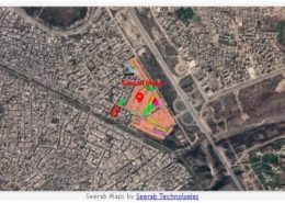 https://www.seerab.com/wp-content/uploads/2022/04/judicial-colony-rawalpindi-map.jpg
368
973
Author
https://seerab.com/wp-content/uploads/2017/04/Seerab-Logo-Landscape-Website-300x113.png
Author2022-04-12 18:21:542022-11-09 16:21:45Judicial Colony Rawalpindi Map
https://www.seerab.com/wp-content/uploads/2022/04/judicial-colony-rawalpindi-map.jpg
368
973
Author
https://seerab.com/wp-content/uploads/2017/04/Seerab-Logo-Landscape-Website-300x113.png
Author2022-04-12 18:21:542022-11-09 16:21:45Judicial Colony Rawalpindi Map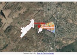 https://www.seerab.com/wp-content/uploads/2022/04/dha-phase-3-npchs-islamabad-rawalpindi-map.jpg
366
973
Author
https://seerab.com/wp-content/uploads/2017/04/Seerab-Logo-Landscape-Website-300x113.png
Author2022-04-10 17:16:262022-06-07 16:15:41Dha Phase 3 NPCHS Islamabad Rawalpindi Map
https://www.seerab.com/wp-content/uploads/2022/04/dha-phase-3-npchs-islamabad-rawalpindi-map.jpg
366
973
Author
https://seerab.com/wp-content/uploads/2017/04/Seerab-Logo-Landscape-Website-300x113.png
Author2022-04-10 17:16:262022-06-07 16:15:41Dha Phase 3 NPCHS Islamabad Rawalpindi Map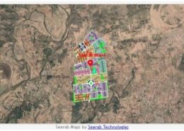 https://www.seerab.com/wp-content/uploads/2022/01/kingdom-valley-map.jpg
367
971
Author
https://seerab.com/wp-content/uploads/2017/04/Seerab-Logo-Landscape-Website-300x113.png
Author2022-01-20 01:34:162022-11-09 18:37:37Kingdom Valley Map
https://www.seerab.com/wp-content/uploads/2022/01/kingdom-valley-map.jpg
367
971
Author
https://seerab.com/wp-content/uploads/2017/04/Seerab-Logo-Landscape-Website-300x113.png
Author2022-01-20 01:34:162022-11-09 18:37:37Kingdom Valley Map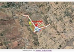 https://www.seerab.com/wp-content/uploads/2022/01/gandhara-city-map.jpg
367
973
Author
https://seerab.com/wp-content/uploads/2017/04/Seerab-Logo-Landscape-Website-300x113.png
Author2022-01-03 23:13:522022-11-09 19:48:34Gandhara City Map
https://www.seerab.com/wp-content/uploads/2022/01/gandhara-city-map.jpg
367
973
Author
https://seerab.com/wp-content/uploads/2017/04/Seerab-Logo-Landscape-Website-300x113.png
Author2022-01-03 23:13:522022-11-09 19:48:34Gandhara City Map