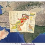
Geology of Pakistan 1964 Map
Historical Geological Map of Pakistan
Historical Map – Geological Map
Geological Map of Pakistan. (East and West Pakistan).
Geological map of Pakistan, showing international, divisional and district boundaries, transportation, water features and populated places. Relief shown by spot heights.
Geology of Pakistan includes correlation section diagrams of various basins, with index map and list of sources, list of sources of the geological compitation with index map, diagram of sub divisions with explanation, [inset of East Pakistan, now Bangladesh], map of Pakistan & surrounding area.
Geological Map prepared as part of the mineral exploration and development programme sponsored by the government of Pakistan and the United States Agency for International Development.
 https://www.seerab.com/wp-content/uploads/2023/09/geology-of-pakistan-1964-map.webp
365
972
Author
https://seerab.com/wp-content/uploads/2017/04/Seerab-Logo-Landscape-Website-300x113.png
Author2023-09-15 10:58:472023-09-15 11:16:47Geology of Pakistan 1964 Map
https://www.seerab.com/wp-content/uploads/2023/09/geology-of-pakistan-1964-map.webp
365
972
Author
https://seerab.com/wp-content/uploads/2017/04/Seerab-Logo-Landscape-Website-300x113.png
Author2023-09-15 10:58:472023-09-15 11:16:47Geology of Pakistan 1964 Map https://www.seerab.com/wp-content/uploads/2022/05/islamabad-rawalpindi-geological-map.jpg
367
974
Author
https://seerab.com/wp-content/uploads/2017/04/Seerab-Logo-Landscape-Website-300x113.png
Author2022-05-01 01:32:042023-09-15 11:26:31Islamabad Rawalpindi Geological Map
https://www.seerab.com/wp-content/uploads/2022/05/islamabad-rawalpindi-geological-map.jpg
367
974
Author
https://seerab.com/wp-content/uploads/2017/04/Seerab-Logo-Landscape-Website-300x113.png
Author2022-05-01 01:32:042023-09-15 11:26:31Islamabad Rawalpindi Geological Map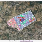
 Seerab Tech