Housing Society Maps – Islamabad
Master Plan Housing Society Maps | Real Estate Maps
Discover detailed housing societies, industrial estates, patwar revenue & cadastral, city & unban master plans, major roads avenues highways motorways & infrastructure, historical & geological maps for Islamabad, including master plans, plot layouts & layout plan (LoPs), road networks, and sectors layout & boundaries. Whether you’re a real estate professionals, investors, real estate developer, urban planner, government bodies or buyer, Seerab Maps offer essential insights into approved and developing projects across the city. Updated regularly, each map highlights key zones, accessibility routes, and land-use divisions to support better decision-making.
🔍 Seerab Maps – Pakistan’s Leading Geospatial PropTech Solution for Real Estate, Urban Planning & Development Monitoring
💼 Why Seerab Maps?
✔ Trusted since 2016
✔ P@SHA ICT Award Winner 2018 – Best Innovation in Real Estate
✔ Finalist – UberPitch 2018
✔ Real-time online & on-site plot verification
✔ Reliable geospatial insights for urban development, planning, and investment security
💡 Don’t fall for deceptive property marketing. With Seerab Maps, know exactly where your plot lies, its surroundings, and ongoing development—before you invest.
Islamabad is a growing hub of modern housing societies and infrastructure. Seerab Maps showcase approved layouts, development status, and planning visuals for both private and public schemes across the district.
 https://www.seerab.com/wp-content/uploads/2021/08/faisal-residencia-map.jpg
364
974
Author
https://seerab.com/wp-content/uploads/2017/04/Seerab-Logo-Landscape-Website-300x113.png
Author2021-09-03 17:42:152022-11-09 21:47:23Faisal Residencia Map
https://www.seerab.com/wp-content/uploads/2021/08/faisal-residencia-map.jpg
364
974
Author
https://seerab.com/wp-content/uploads/2017/04/Seerab-Logo-Landscape-Website-300x113.png
Author2021-09-03 17:42:152022-11-09 21:47:23Faisal Residencia Map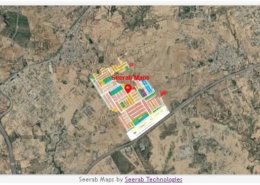 https://www.seerab.com/wp-content/uploads/2021/08/supreme-court-employees-housing-society-g-17-map.jpg
366
971
Author
https://seerab.com/wp-content/uploads/2017/04/Seerab-Logo-Landscape-Website-300x113.png
Author2021-08-27 00:26:402022-11-09 22:16:43Supreme Court Employees Co-operative Housing Society Islamabad Map
https://www.seerab.com/wp-content/uploads/2021/08/supreme-court-employees-housing-society-g-17-map.jpg
366
971
Author
https://seerab.com/wp-content/uploads/2017/04/Seerab-Logo-Landscape-Website-300x113.png
Author2021-08-27 00:26:402022-11-09 22:16:43Supreme Court Employees Co-operative Housing Society Islamabad Map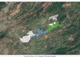 https://www.seerab.com/wp-content/uploads/2021/06/pakistan-vaval-farms-master-plan-map.jpg
363
972
Author
https://seerab.com/wp-content/uploads/2017/04/Seerab-Logo-Landscape-Website-300x113.png
Author2021-06-26 19:34:442022-05-31 15:31:17Pakistan Naval Farms Master Plan Map
https://www.seerab.com/wp-content/uploads/2021/06/pakistan-vaval-farms-master-plan-map.jpg
363
972
Author
https://seerab.com/wp-content/uploads/2017/04/Seerab-Logo-Landscape-Website-300x113.png
Author2021-06-26 19:34:442022-05-31 15:31:17Pakistan Naval Farms Master Plan Map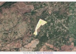 https://www.seerab.com/wp-content/uploads/2021/05/islamabad-model-town-map.jpg
366
972
Author
https://seerab.com/wp-content/uploads/2017/04/Seerab-Logo-Landscape-Website-300x113.png
Author2021-05-24 00:58:592022-09-05 11:56:49Islamabad Model Town Map
https://www.seerab.com/wp-content/uploads/2021/05/islamabad-model-town-map.jpg
366
972
Author
https://seerab.com/wp-content/uploads/2017/04/Seerab-Logo-Landscape-Website-300x113.png
Author2021-05-24 00:58:592022-09-05 11:56:49Islamabad Model Town Map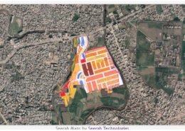 https://www.seerab.com/wp-content/uploads/2021/05/rahman-enclave-map.jpg
367
972
Author
https://seerab.com/wp-content/uploads/2017/04/Seerab-Logo-Landscape-Website-300x113.png
Author2021-05-24 00:39:132022-05-31 15:30:31Rahman Enclave Map
https://www.seerab.com/wp-content/uploads/2021/05/rahman-enclave-map.jpg
367
972
Author
https://seerab.com/wp-content/uploads/2017/04/Seerab-Logo-Landscape-Website-300x113.png
Author2021-05-24 00:39:132022-05-31 15:30:31Rahman Enclave Map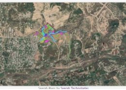 https://www.seerab.com/wp-content/uploads/2021/05/workers-welfare-fund-labor-colony-map.jpg
365
972
Author
https://seerab.com/wp-content/uploads/2017/04/Seerab-Logo-Landscape-Website-300x113.png
Author2021-05-22 23:07:532022-05-31 15:30:06Workers Welfare Fund Labor Colony Map
https://www.seerab.com/wp-content/uploads/2021/05/workers-welfare-fund-labor-colony-map.jpg
365
972
Author
https://seerab.com/wp-content/uploads/2017/04/Seerab-Logo-Landscape-Website-300x113.png
Author2021-05-22 23:07:532022-05-31 15:30:06Workers Welfare Fund Labor Colony Map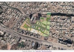 https://www.seerab.com/wp-content/uploads/2021/05/al-ghurair-giga-map.jpg
365
973
Author
https://seerab.com/wp-content/uploads/2017/04/Seerab-Logo-Landscape-Website-300x113.png
Author2021-05-20 12:12:542022-05-31 15:28:42Al Ghurair Giga Map
https://www.seerab.com/wp-content/uploads/2021/05/al-ghurair-giga-map.jpg
365
973
Author
https://seerab.com/wp-content/uploads/2017/04/Seerab-Logo-Landscape-Website-300x113.png
Author2021-05-20 12:12:542022-05-31 15:28:42Al Ghurair Giga Map https://www.seerab.com/wp-content/uploads/2021/05/capital-enclave-map.jpg
366
973
Author
https://seerab.com/wp-content/uploads/2017/04/Seerab-Logo-Landscape-Website-300x113.png
Author2021-05-20 12:04:042022-05-31 15:28:09Capital Enclave Map
https://www.seerab.com/wp-content/uploads/2021/05/capital-enclave-map.jpg
366
973
Author
https://seerab.com/wp-content/uploads/2017/04/Seerab-Logo-Landscape-Website-300x113.png
Author2021-05-20 12:04:042022-05-31 15:28:09Capital Enclave Map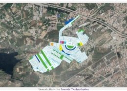 https://www.seerab.com/wp-content/uploads/2021/05/engineers-housing-scheme-map.jpg
366
973
Author
https://seerab.com/wp-content/uploads/2017/04/Seerab-Logo-Landscape-Website-300x113.png
Author2021-05-18 15:13:372022-05-31 15:27:49Engineers Housing Scheme Map
https://www.seerab.com/wp-content/uploads/2021/05/engineers-housing-scheme-map.jpg
366
973
Author
https://seerab.com/wp-content/uploads/2017/04/Seerab-Logo-Landscape-Website-300x113.png
Author2021-05-18 15:13:372022-05-31 15:27:49Engineers Housing Scheme Map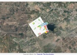 https://www.seerab.com/wp-content/uploads/2021/05/margalla-view-housing-society-map.jpg
363
972
Author
https://seerab.com/wp-content/uploads/2017/04/Seerab-Logo-Landscape-Website-300x113.png
Author2021-05-18 14:54:062022-05-31 15:27:25Margalla View Housing Society Map
https://www.seerab.com/wp-content/uploads/2021/05/margalla-view-housing-society-map.jpg
363
972
Author
https://seerab.com/wp-content/uploads/2017/04/Seerab-Logo-Landscape-Website-300x113.png
Author2021-05-18 14:54:062022-05-31 15:27:25Margalla View Housing Society Map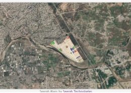 https://www.seerab.com/wp-content/uploads/2021/05/river-garden-map.jpg
364
972
Author
https://seerab.com/wp-content/uploads/2017/04/Seerab-Logo-Landscape-Website-300x113.png
Author2021-05-16 23:20:482022-05-31 15:27:05River Garden Map
https://www.seerab.com/wp-content/uploads/2021/05/river-garden-map.jpg
364
972
Author
https://seerab.com/wp-content/uploads/2017/04/Seerab-Logo-Landscape-Website-300x113.png
Author2021-05-16 23:20:482022-05-31 15:27:05River Garden Map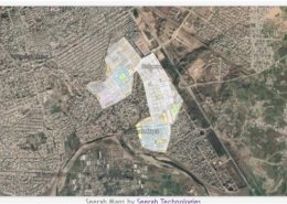 https://www.seerab.com/wp-content/uploads/2021/05/soan-gardens-map.jpg
363
972
Author
https://seerab.com/wp-content/uploads/2017/04/Seerab-Logo-Landscape-Website-300x113.png
Author2021-05-16 23:12:532022-05-31 15:26:33Soan Gardens Map
https://www.seerab.com/wp-content/uploads/2021/05/soan-gardens-map.jpg
363
972
Author
https://seerab.com/wp-content/uploads/2017/04/Seerab-Logo-Landscape-Website-300x113.png
Author2021-05-16 23:12:532022-05-31 15:26:33Soan Gardens Map