Housing Society Maps – Islamabad
Master Plan Housing Society Maps | Real Estate Maps
Discover detailed housing societies, industrial estates, patwar revenue & cadastral, city & unban master plans, major roads avenues highways motorways & infrastructure, historical & geological maps for Islamabad, including master plans, plot layouts & layout plan (LoPs), road networks, and sectors layout & boundaries. Whether you’re a real estate professionals, investors, real estate developer, urban planner, government bodies or buyer, Seerab Maps offer essential insights into approved and developing projects across the city. Updated regularly, each map highlights key zones, accessibility routes, and land-use divisions to support better decision-making.
🔍 Seerab Maps – Pakistan’s Leading Geospatial PropTech Solution for Real Estate, Urban Planning & Development Monitoring
💼 Why Seerab Maps?
✔ Trusted since 2016
✔ P@SHA ICT Award Winner 2018 – Best Innovation in Real Estate
✔ Finalist – UberPitch 2018
✔ Real-time online & on-site plot verification
✔ Reliable geospatial insights for urban development, planning, and investment security
💡 Don’t fall for deceptive property marketing. With Seerab Maps, know exactly where your plot lies, its surroundings, and ongoing development—before you invest.
Islamabad is a growing hub of modern housing societies and infrastructure. Seerab Maps showcase approved layouts, development status, and planning visuals for both private and public schemes across the district.
 https://www.seerab.com/wp-content/uploads/2020/05/g-13-islamabad.jpg
434
1189
Author
https://seerab.com/wp-content/uploads/2017/04/Seerab-Logo-Landscape-Website-300x113.png
Author2020-05-21 15:17:362022-05-31 15:18:55G-13 Islamabad Map
https://www.seerab.com/wp-content/uploads/2020/05/g-13-islamabad.jpg
434
1189
Author
https://seerab.com/wp-content/uploads/2017/04/Seerab-Logo-Landscape-Website-300x113.png
Author2020-05-21 15:17:362022-05-31 15:18:55G-13 Islamabad Map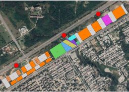 https://www.seerab.com/wp-content/uploads/2020/05/new-blue-area-islamabad-map.jpg
428
1192
Author
https://seerab.com/wp-content/uploads/2017/04/Seerab-Logo-Landscape-Website-300x113.png
Author2020-05-19 02:22:062022-05-31 15:16:56New Blue Area Islamabad Map
https://www.seerab.com/wp-content/uploads/2020/05/new-blue-area-islamabad-map.jpg
428
1192
Author
https://seerab.com/wp-content/uploads/2017/04/Seerab-Logo-Landscape-Website-300x113.png
Author2020-05-19 02:22:062022-05-31 15:16:56New Blue Area Islamabad Map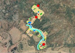 https://www.seerab.com/wp-content/uploads/2020/05/nhf-housing-scheme-map.jpg
424
1188
Author
https://seerab.com/wp-content/uploads/2017/04/Seerab-Logo-Landscape-Website-300x113.png
Author2020-05-03 06:08:182022-05-31 15:16:32NHF Housing Scheme Map
https://www.seerab.com/wp-content/uploads/2020/05/nhf-housing-scheme-map.jpg
424
1188
Author
https://seerab.com/wp-content/uploads/2017/04/Seerab-Logo-Landscape-Website-300x113.png
Author2020-05-03 06:08:182022-05-31 15:16:32NHF Housing Scheme Map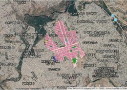 https://www.seerab.com/wp-content/uploads/2019/11/police-foundation-rawalpindi.jpg
452
1213
Author
https://seerab.com/wp-content/uploads/2017/04/Seerab-Logo-Landscape-Website-300x113.png
Author2019-11-25 23:08:022022-05-31 15:16:01Police Foundation Rawalpindi Islamabad Map
https://www.seerab.com/wp-content/uploads/2019/11/police-foundation-rawalpindi.jpg
452
1213
Author
https://seerab.com/wp-content/uploads/2017/04/Seerab-Logo-Landscape-Website-300x113.png
Author2019-11-25 23:08:022022-05-31 15:16:01Police Foundation Rawalpindi Islamabad Map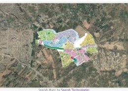 https://www.seerab.com/wp-content/uploads/2019/11/dha-phase-5-islamabad-rawalpindi.jpg
365
973
Author
https://seerab.com/wp-content/uploads/2017/04/Seerab-Logo-Landscape-Website-300x113.png
Author2019-11-17 23:34:032022-10-02 22:56:20Dha Phase 5 Islamabad Rawalpindi Map
https://www.seerab.com/wp-content/uploads/2019/11/dha-phase-5-islamabad-rawalpindi.jpg
365
973
Author
https://seerab.com/wp-content/uploads/2017/04/Seerab-Logo-Landscape-Website-300x113.png
Author2019-11-17 23:34:032022-10-02 22:56:20Dha Phase 5 Islamabad Rawalpindi Map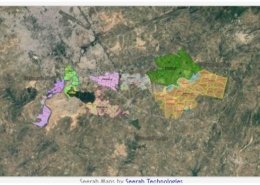 https://www.seerab.com/wp-content/uploads/2019/11/dha-islamabad-rawalpindi-master-plan-e1572808461388.jpg
367
973
Author
https://seerab.com/wp-content/uploads/2017/04/Seerab-Logo-Landscape-Website-300x113.png
Author2019-11-04 00:17:502022-06-07 16:00:15Dha Islamabad Rawalpindi Master Plan Map
https://www.seerab.com/wp-content/uploads/2019/11/dha-islamabad-rawalpindi-master-plan-e1572808461388.jpg
367
973
Author
https://seerab.com/wp-content/uploads/2017/04/Seerab-Logo-Landscape-Website-300x113.png
Author2019-11-04 00:17:502022-06-07 16:00:15Dha Islamabad Rawalpindi Master Plan Map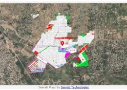 https://www.seerab.com/wp-content/uploads/2019/11/jinnah-garden.jpg
368
974
Author
https://seerab.com/wp-content/uploads/2017/04/Seerab-Logo-Landscape-Website-300x113.png
Author2019-11-03 23:22:262022-05-30 00:51:53Jinnah Garden Map
https://www.seerab.com/wp-content/uploads/2019/11/jinnah-garden.jpg
368
974
Author
https://seerab.com/wp-content/uploads/2017/04/Seerab-Logo-Landscape-Website-300x113.png
Author2019-11-03 23:22:262022-05-30 00:51:53Jinnah Garden Map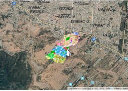 https://www.seerab.com/wp-content/uploads/2019/08/zaraj-housing.jpg
459
1216
Author
https://seerab.com/wp-content/uploads/2017/04/Seerab-Logo-Landscape-Website-300x113.png
Author2019-08-22 23:35:242022-05-31 15:17:16Zaraj Housing Map
https://www.seerab.com/wp-content/uploads/2019/08/zaraj-housing.jpg
459
1216
Author
https://seerab.com/wp-content/uploads/2017/04/Seerab-Logo-Landscape-Website-300x113.png
Author2019-08-22 23:35:242022-05-31 15:17:16Zaraj Housing Map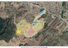 https://www.seerab.com/wp-content/uploads/2019/08/agochs-ii-map.jpg
363
973
Author
https://seerab.com/wp-content/uploads/2017/04/Seerab-Logo-Landscape-Website-300x113.png
Author2019-08-22 23:27:052022-05-31 12:47:07Agochs ii Map
https://www.seerab.com/wp-content/uploads/2019/08/agochs-ii-map.jpg
363
973
Author
https://seerab.com/wp-content/uploads/2017/04/Seerab-Logo-Landscape-Website-300x113.png
Author2019-08-22 23:27:052022-05-31 12:47:07Agochs ii Map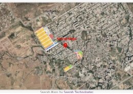 https://www.seerab.com/wp-content/uploads/2019/06/pmchs-islamabad-map.jpg
365
972
Author
https://seerab.com/wp-content/uploads/2017/04/Seerab-Logo-Landscape-Website-300x113.png
Author2019-06-19 00:43:442022-05-31 12:46:45PMCHS Islamabad Map – E-11/2
https://www.seerab.com/wp-content/uploads/2019/06/pmchs-islamabad-map.jpg
365
972
Author
https://seerab.com/wp-content/uploads/2017/04/Seerab-Logo-Landscape-Website-300x113.png
Author2019-06-19 00:43:442022-05-31 12:46:45PMCHS Islamabad Map – E-11/2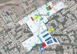 https://www.seerab.com/wp-content/uploads/2019/06/schs-map-islamabad-e1560885892148.jpg
200
200
Author
https://seerab.com/wp-content/uploads/2017/04/Seerab-Logo-Landscape-Website-300x113.png
Author2019-06-19 00:26:322022-05-31 12:46:24SCHS Map Islamabad – E-11/2
https://www.seerab.com/wp-content/uploads/2019/06/schs-map-islamabad-e1560885892148.jpg
200
200
Author
https://seerab.com/wp-content/uploads/2017/04/Seerab-Logo-Landscape-Website-300x113.png
Author2019-06-19 00:26:322022-05-31 12:46:24SCHS Map Islamabad – E-11/2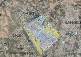 https://www.seerab.com/wp-content/uploads/2019/05/g-15-islamabad-e1559250062475.jpg
200
200
Author
https://seerab.com/wp-content/uploads/2017/04/Seerab-Logo-Landscape-Website-300x113.png
Author2019-05-31 02:02:252022-05-30 00:50:09G-15 Islamabad Map
https://www.seerab.com/wp-content/uploads/2019/05/g-15-islamabad-e1559250062475.jpg
200
200
Author
https://seerab.com/wp-content/uploads/2017/04/Seerab-Logo-Landscape-Website-300x113.png
Author2019-05-31 02:02:252022-05-30 00:50:09G-15 Islamabad Map