Computer Aided Design and Drafting (CAD)

Posts

Why should I switch from CAD to BIM

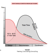
Why should I switch from CAD to BIM?

BIM and CAD represent two fundamentally different approaches to building design and documentation.

CAD (Computer Aided Design) applications imitate the traditional “paper & pencil” process in so far as two-dimensional electronic drawings are created from 2D graphic elements such as lines, hatches and text, etc. CAD drawings, similarly to traditional paper drawings, are created independently from each other so design changes need to be followed up and implemented manually on each CAD drawing.

BIM (Building Information Modeling) applications imitate the real building process. Instead of creating drawings from 2D line-work, buildings are virtually modeled from real construction elements such as walls, windows, slabs and roofs, etc. This allows architects to design buildings in a similar way as they are built. Since all data is stored in the central virtual building model, design changes are automatically followed-up on individual drawings generated from the model. With this integrated model approach, BIM not only offers significant productivity increase but also serves as the basis for better-coordinated designs and a computer model based building process. While switching from CAD to BIM is already justified by the benefits achieved during the design phase BIM offers further benefits during the construction and operation of buildings.

AutoCAD Map 3D

AutoCAD Map 3D vs AutoCAD

Compare AutoCAD Map 3D vs. AutoCAD

AutoCAD Map 3D is GIS mapping software that includes the tools and functionality of AutoCAD.

AutoCAD Map 3D

Utilize and maintain CAD and GIS data to support planning, design, and data management.

USE FOR:
GIS analysis and planning
Gathering existing conditions data
Converting GIS data into CAD data

WHAT IT DOES:
Create thematic maps for analysis
Perform data queries
Build topologies
Utilize georeferenced Imagery
Connect to multiple external data sources

LICENSING:
Single-user
Multi-user (networked) licenses available

INCLUDES:
A360 collaboration tool
AutoCAD mobile app

https://www.autodesk.com/products/autocad-map-3d/overview

AutoCAD

Design every detail with 2D and 3D CAD software. Share drawings across desktop, cloud, and mobile.

USE FOR:
2D drafting, drawings, and documentation
3D modeling and visualization

WHAT IT DOES:
Create and edit 2D geometry.
Create and edit 3D models with solids, surfaces, and mesh objects.
Annotate drawings with text, dimensions, leaders, and tables.
Customize the ribbon and tool palettes.
Customize with add-on apps and APIs.
Extract object data to tables.
Attach and import data from PDF files.
Share and use data from and DGN files, Navisworks, and Bing Maps.
Apply and monitor CAD standards.

LICENSING:
Single-user
Multi-user (network)

INCLUDES:
Access to the Autodesk App Store
AutoCAD mobile app

https://www.autodesk.com/products/autocad/overview

Best Software to Bridge the Gap between CAD & GIS

Best Software to Bridge the Gap between CAD & GIS

Geographic Information Systems (GIS) development is now a norm around the world. Clients like government agencies, municipalities ask all project data in GIS ready file format so they can update their national GIS. Engineering new data is created & existing data is available in Computer Aided Drafting & Designing (CAD) software’s in DWG (Autodesk AutoCAD) or DGN (Bentley Systems MicroStation) file formats. CAD file format can store multiple objects, geometry types etc. point, line, polygon, circle, arc and blocks altogether at in one file. GIS file can store one type of object, geometry in one file and store point, line and polygon separately. CAD to GIS data conversion is big task and now a days in demand skill.

Autodesk product AutoCAD Map 3D is the best software for AutoCAD users to bridge the gap between CAD & GIS. AutoCAD Map 3D has same AutoCAD working environment that AutoCAD user are familiar with. So it easy to learn to AutoCAD users, they just have to learn only AutoCAD Map 3D tools. It has complete set of tools to inspect, edit, modify, convert, export CAD objects, geometry to GIS and vice versa. AutoCAD Map 3D is standalone product, it is built on AutoCAD and has added features of AutoCAD Map 3D. AutoCAD Map 3D is also embedded in AutoCAD Civil 3D (Civil Engineering Building Information Modeling (BIM) software).

Stay tuned with Seerab …. Work Smart by improving YOUR skills