ArcMap-will-be-replaced-with-ArcGIS-Pro

ArcMap will be replaced by ArcGIS Pro

In the questions and answers session of Esri UC 2017 Q & A, there has been concern about the future of ArcMap. Because Esri’s new generation desktop GIS product is ArcGIS Pro. It is advancing by leaps and bounds and technologically advanced to any other product on the market, this powerful application provides professional mapping functions, advanced analysis and data management.

In addition, developed in a 64-bit architecture, to enjoy and explore the new advantages and features that migrate to ArcGIS Pro is required to log in with an account subscribed to ArcGIS Online. Then the million dollar question would be:

Will ArcMap be replaced with ArcGIS Pro?

Yes. ArcGIS Pro will eventually replace ArcMap. We will continue to support and maintain ArcMap. However, our focus is on making ArcGIS Pro the world’s best desktop GIS. There are still some capabilities of ArcMap that are not yet in ArcGIS Pro, so some ArcGIS Desktop users will be using both ArcGIS Pro and ArcMap till Pro has everything you need to fully support your work.

This response has been published in Esri UC 2017 Q&A, although there will be a whole process of accompaniment in the migration, but sadly the life of ArcMap with technical support is scheduled until 2022.

Although after that time I think there will be a lot of users who keep using ArcMap, simply because if it works well and you are comfortable there would be no reason to change. This has happened with some users who are still reluctant to abandon ArcView 3.

We only have to wait for the future how ArcMap lovers will react, I think it is good to adapt to changes and explore new opportunities, each one is free to make a decision, but living from the past is not always the best option.

What’s New in ArcMap 10.5.1?

What’s New in ArcMap 10.5.1?

What’s New in ArcMap 10.5.1?

ArcMap 10.5.1 is a quality improvement release focused on increasing performance and fixing bugs. Improvements include

  • Enhancements to the Slope and Aspect tools in the Spatial Analyst extension and the Raster Surface toolset in the 3D Analyst extension.
  • Updates to the Append Control Points, Build Pyramids and Statistics, and Transfer Attributes tools.
  • New product types and processing templates for some Airbus and DigitalGlobe sensors.
  • Improved support for the PostgreSQL database.
  • Fixes addressing the unique requirements of localized versions of ArcMap.

Get the full details on what’s new in ArcMap 10.5.1.

#Esri #ArcGIS #ArcMap

ArcGIS Pro 2

ArcGIS Pro 2.0

ArcGIS Pro 2.0

ArcGIS Pro 2.0, the next release of Esri’s flagship 64-bit desktop GIS application, has been released and is available from My Esri. ArcGIS Pro 2.0 continues Esri’s mission to provide new and user-requested functionality, the latest innovations for working with 2D and 3D spatial data, tools for performing advanced analytics, and enhanced support across the ArcGIS platform.

Highly Requested Workflows

Your favorite workflows are now easier and more powerful in ArcGIS Pro 2.0. You can now perform more complete workflows solely in ArcGIS Pro, such as map creation and data management.

  • Create more effective and meaningful maps with annotation and grids.
  • Getting started with new ArcGIS Pro projects has vastly improved with Favorites.
  • Modify your topology properties directly in ArcGIS Pro.
  • Enhanced traverse tool improves your COGO workflows.
  • Highly requested context menu options for importing and exporting data included in the Catalog pane.

Unique Innovations

ArcGIS Pro 2.0 features unique innovations that cannot be found in any other desktop GIS.

  • Easily explore your 3D landscapes with the new innovative 3D navigation controls and sync the views of your 3D and 2D maps.
  • Your layouts are more useful and powerful than ever with embeddable dynamic interactive charts.
  • Improvements to 3D drawing including feature drawing by camera distance and enhanced lighting of 3D objects make your 3D visualizations even better.
  • Analytics Improvements with fill missing values tools and enhanced spacetime cubes.
  • Get more done with new geoprocessing tools only available in ArcGIS Pro.

ArcGIS Platform Integration

ArcGIS Pro 2.0 works better with the rest of the ArcGIS platform, including ArcGIS Online, ArcGIS Enterprise, and Esri’s vast library of ready-to-use apps. Your cross-platform workflows are now easier and more powerful than ever.

  • Enhancements for editing and interacting with the geodatabase in the ArcGIS Pro 2.0 SDK.
  • Consume native OGC Web Feature Service (WFS) Services directly in ArcGIS Pro.
  • Sync with feature layers that reference data registered in Portal for ArcGIS 10.5.1.
  • Vertical coordinate systems are included when sharing web scenes and web scene layers.
  • Continue to work in ArcGIS Pro while packaging operations complete in the background.

Get the full details on what’s new in ArcGIS Pro 2.0.

#Esri #ArcGISPro #GIS

GIS Quotes

GIS Quote – Peter

“I’ve always been fascinated by maps and cartography.  A map tells you where you’ve been, where you are, and where you’re going — in a sense it’s three tenses in one.”

Peter Greenaway
Welsh film director in an interview for Film Comment, May/June 1990

What is the ArcGIS 3D Analyst extension

What is the ArcGIS 3D Analyst extension?

What is the ArcGIS 3D Analyst extension?

Three-dimensional visualization and analysis; includes ArcGlobe and ArcScene applications. Also includes terrain data management and geoprocessing tools.

ArcGIS 3D Analyst extends ArcGIS to be a fully functioning 3D GIS system. It allows you to view, manage, analyze, and share your 3D GIS data.

  • View huge volumes of 3D GIS data in a global view using ArcGlobe, or view site-level data in a local coordinate system using ArcScene.
  • Manage 3D GIS data by editing features directly inside ArcGlobe or ArcScene, and add 3D components to 2D data through geoprocessing tools.
  • Analyze GIS data in three dimensions using geoprocessing tools, and use interactive tools in a 3D view.
  • Share 3D views of GIS data by publishing Globe Services and share 3D analytic tools through geoprocessing services.

3D Analyst

Esri

The challenges that BIM creates

The challenges that BIM creates

For all its benefits, BIM brings new challenges around creating and collaborating on models:

  1. Taking the model beyond the design team – The true value of BIM can only be realized when it is taken beyond the design team – to subcontractors, the owner and facility manager. Providing access to the model and allowing them to contribute and link other information are key.
  2. Viewing the model (including in the field) – How can a subcontractor be given a view of a particular part of the model to resolve an issue without having to download and install software? How can people collaborate around that view quickly and easily? How can they view it on the tablet when standing on the site?
  3. Linking models to other data – A lot of project information, like drawings, RFIs and spec sheets, lives outside the model. How can these documents be linked for a more complete model? Owners may insist on receiving a 3D model but, for the full picture, it should be linked to all of the other data created and collated on the project.
  4. Tracking approvals and audit trails – Models are generated by different authoring tools and constantly changing, making it difficult to obtain and record approvals. With hundreds of decisions made around the model during its life, maintaining an audit trail of who did what and when can be almost impossible.
  5. Managing large file sizes – When BIM models can easily reach 50MB or more, distributing files securely and efficiently can be difficult, if not impossible. E-mail can’t handle the file sizes and FTP sites don’t provide the access control or audit trail you need.
  6. Model management – Typically, people on a project work with different authoring tools. The BIM Manager then compiles and distributes the federated model. This might happen on a weekly cycle, which can be too slow for a fast-moving project. Allowing each party to contribute its model as needed, while others access the information in real time, makes BIM more valuable to everyone.
  7. Dealing with long review cycles – Clash resolution usually takes place at set intervals, such as weekly or twice a month. But this creates a lag, where somebody addressing a clash has to wait for a whole cycle to complete before knowing whether it has been fixed or not. Immediate, real-time resolution of clashes is required.
  8. Publishing slices of models – No matter how advanced your 3D modeling is, there is still the requirement to publish, distribute and track the 2D plans which are needed for set-out and construction.
  9. Archiving point-in-time models – Even when a 3D software package can track changes, there still needs to be a way to save point-in-time models for sign-off and approval purposes.
  10. Handover of a complete and accurate model – Owners want to receive a full set of information to run their facility. And contractors and consultants want to be sure they have met their contractual requirements in order to get paid. So understanding when this point has been reached is in everyone’s interest.

#Building Information Modeling #BIM #CAD

What do I need to keep in mind when selecting my BIM tool?

What do I need to keep in mind when selecting my BIM tool?

What do I need to keep in mind when selecting my BIM tool?
Although there are several model-based design solutions available on the market today, it is important to note that not all solutions can equally fulfill the requirements for being a true BIM solution. The following set of questions help you judge if a certain solution has all the characteristics that set cutting edge BIM solutions apart from the rest of the pack:

What is the “depth” of the BIM model supported?
Optimally, the BIM model should be able to serve all deliverables during the entire building project lifecycle. There are various levels and depths to creating 3D building models starting from mass models used for schematic design through 3D models created for visualization purposes to intelligent “real” building information models. While models created for visualization only contain not more than the 3D geometry and material descriptions necessary for the realistic presentation of the building, real BIM models, in addition to the geometry, also contain an abundance of additional information necessary to coordinate, document, list and manage the building based upon its intelligent BIM model.

Does the BIM solution cover the complete workflow?
As noted above, “real” BIM models should incorporate all information necessary to create the deliverables during the building projects’ lifecycle. This also means that the BIM authoring tool should cover the complete BIM workflow without the need for changing tools and/or workflows in the middle of the project. Hence it is a vital question whether the design, documentation, realization and operation of the building is supported by the BIM tool beginning with conceptual design through design development, construction documentation to construction administration & management and ultimately facility management.

At what level does the BIM solution support interoperability?
In addition to being compatible with the world at the binary level (file compatibility) BIM tools also need to be compatible with one another at the process or workflow level. This is especially true in the event of interdisciplinary design teams that need to collaborate on the different design aspects of the same building. When selecting your BIM tool it is mission critical whether your BIM tool supports open standards and open workflows that enable coordination with consultants — regardless of the type or version of their selected design application (BIM tool). To learn more about “openBIM” design workflows please visit www.graphisoft.com/openbim?

Does the BIM solution support real-time model-based collaboration?
Building design is a team process in most cases. So should be BIM as well. This is, however, not a given, as BIM models are much more tightly integrated than traditional CAD drawing-based projects. Sharing design in BIM requires a whole new approach that involves active BIM servers that offer parallel, “real-time” access for an entire team. When selecting your BIM tool it is a question of strategic importance whether the BIM model and the process to creating it are designed in a way that supports real-time sharing for teams and projects of any size. To learn more about model based design sharing with the cutting-edge GRAPHISOFT BIM Server visit www.graphisoft.com/bimserver.

Does the BIM solution sufficient performance for large/complex projects?
As noted above, the BIM model is much more tightly integrated and includes much more data than traditional CAD drawings. This necessarily implies that project-size growth has an exponential relation with the performance requirements. Whether a BIM solution can handle that growth depends on various factors including its ability to utilize latest hardware enhancements and the way it handles the model. When selecting your BIM tool it is an absolutely valid question what the maximum possible project size is allowed/recommended and whether advanced IT technologies such as 64-bit and multiprocessing technologies are supported at the same time throughout the entire application.

Does the BIM solution support local standards and offer sufficient local content?
Building projects are not only unique design pieces but the way they are designed varies between countries. Global BIM solution providers handle the issue of “localization” at different levels. Language translation is really not localization – it is only what its name suggests. When selecting your BIM tool it is your primary interest to be fully aware whether a BIM solution follows local design standards and has rich local content including intelligent building objects, local project and listing templates, and attribute sets following local standards.

Why should I switch from CAD to BIM

Why should I switch from CAD to BIM?

BIM and CAD represent two fundamentally different approaches to building design and documentation.

CAD (Computer Aided Design) applications imitate the traditional “paper & pencil” process in so far as two-dimensional electronic drawings are created from 2D graphic elements such as lines, hatches and text, etc. CAD drawings, similarly to traditional paper drawings, are created independently from each other so design changes need to be followed up and implemented manually on each CAD drawing.

BIM (Building Information Modeling) applications imitate the real building process. Instead of creating drawings from 2D line-work, buildings are virtually modeled from real construction elements such as walls, windows, slabs and roofs, etc. This allows architects to design buildings in a similar way as they are built. Since all data is stored in the central virtual building model, design changes are automatically followed-up on individual drawings generated from the model. With this integrated model approach, BIM not only offers significant productivity increase but also serves as the basis for better-coordinated designs and a computer model based building process. While switching from CAD to BIM is already justified by the benefits achieved during the design phase BIM offers further benefits during the construction and operation of buildings.

What is Building Information Modeling (BIM)?

This may come as a surprise, but BIM isn’t new. It first appeared as early as 1962, when Douglas Engelbart wrote his paper “Augmenting Human Intellect: A Conceptual Framework” and described architect entering specifications and data into a building design and watching a structure take shape—a concept very similar to modern parametric modeling.

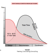
The term “BIM” was first used back in the ‘90s, but the recession put a damper on its early stages. It picked back up after the recession and has really taken off in recent years. Because it was a bit of a late bloomer, BIM might seem like a brand-new and scary thing for dedicated CAD users—but the shift from CAD to BIM has been a long time coming.
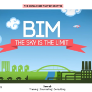
What is BIM?
Building Information Modeling (BIM) is an intelligent 3D model-based process that equips architecture, engineering, and construction professionals with the insight and tools to more efficiently plan, design, construct, and manage buildings and infrastructure.

The Components of BIM

B is for Building.

The key point to remember here is that “building” doesn’t mean “a building.”

BIM can be used for so much more than designing a structure with four walls and a roof. This preconceived notion of “building” comes from its roots—in an etymological sense, it quite literally means “house.”

In order to get the true gist of BIM, however, it helps to think of the word “building” in terms of the verb “to build.”

BIM is a process that involves the act of building something together, whether it relates to architecture, infrastructure, civil engineering, landscaping or other large-scale projects.
I is for Information.

And that information is embedded into every aspect of your project. This is what makes BIM “smart.”

Every project comes with a staggering amount of information, from prices to performance ratings and predicted lifetimes. It tells your project’s life story long before the ground is ever broken and it will help track potential issues throughout your project’s lifetime.

BIM is a way to bring all of these details into one place so it’s easy to keep track of everything.

M is for Modeling

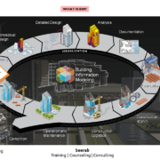
In BIM, every project is built twice—once in a virtual environment to make sure that everything is just right and once in a real environment to bring the project to life.
This step is the overview of every other aspect of the building and its information. It provides the measure or standard for the building project—an analogy or smaller-scale representation of the final appearance and effect. It will continue to model this representation throughout the building’s lifespan.

“We look at the full life-cycle of the building, not just as a design tool but in how it can impact the construction process, how it can impact the management of the building and how it can help inform an owner of the space beyond our involvement in the design process,” said Concannon.

This model can become a tool for the building owner’s reference long after construction is completed, helping to inform maintenance and other decisions.

It’s also the step that will help to sell a concept while condensing all of those other layers of information that show the building’s every detail.

The Bottom Line: What is BIM?
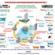
BIM is both a best-practice process and 3D modeling software. By using it, designers can create a shared buildingproject with integrated information in a format that models both the structure and the entire timeline of the project from inception to eventual demolition.

It enables architects and engineers alike to work on a single project from anywhere in the world. It condenses a plethora of information about every detail into a workable format. It facilitates testing and analysis during the design phase to find the best answer to a problem.

It makes for easier design, simpler coordination between team members and easier structure maintenance across the entire built environment—and this is just the beginning.

#Building Information Modeling #BIM #CAD

AutoCAD Map 3D

AutoCAD Map 3D vs AutoCAD

Compare AutoCAD Map 3D vs. AutoCAD

AutoCAD Map 3D is GIS mapping software that includes the tools and functionality of AutoCAD.

AutoCAD Map 3D

Utilize and maintain CAD and GIS data to support planning, design, and data management.

USE FOR:
GIS analysis and planning
Gathering existing conditions data
Converting GIS data into CAD data

WHAT IT DOES:
Create thematic maps for analysis
Perform data queries
Build topologies
Utilize georeferenced Imagery
Connect to multiple external data sources

LICENSING:
Single-user
Multi-user (networked) licenses available

INCLUDES:
A360 collaboration tool
AutoCAD mobile app

https://www.autodesk.com/products/autocad-map-3d/overview

AutoCAD

Design every detail with 2D and 3D CAD software. Share drawings across desktop, cloud, and mobile.

USE FOR:
2D drafting, drawings, and documentation
3D modeling and visualization

WHAT IT DOES:
Create and edit 2D geometry.
Create and edit 3D models with solids, surfaces, and mesh objects.
Annotate drawings with text, dimensions, leaders, and tables.
Customize the ribbon and tool palettes.
Customize with add-on apps and APIs.
Extract object data to tables.
Attach and import data from PDF files.
Share and use data from and DGN files, Navisworks, and Bing Maps.
Apply and monitor CAD standards.

LICENSING:
Single-user
Multi-user (network)

INCLUDES:
Access to the Autodesk App Store
AutoCAD mobile app

https://www.autodesk.com/products/autocad/overview