ARCMAP
ArcMap is where you display and explore GIS datasets for your study area, where you assign symbols, and where you create map layouts for printing or publication. ArcMap is also the application you use to create and edit datasets.
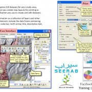
ArcMap represents geographic information as a collection of layers and other elements in a map. Common map elements include the data frame containing map layers for a given extent plus a scale bar, north arrow, title, descriptive text, a symbol legend, and so on.
TYPICAL TASKS PERFORMED IN ARCMAP
ArcMap is the primary application used in ArcGIS and is used to perform a wide range of common GIS tasks as well as specialized, user-specific tasks. Here is a list of some common workflows you can perform:
1-Work with maps—You can open and use ArcMap documents to explore information, navigate around your map documents, turn layers on and off, query features to access the rich attribute data that is behind the map, and to visualize geographic information.
2-Print maps—You can print maps, from the simplest to very sophisticated cartography, using ArcMap.
3-Compile and edit GIS datasets—ArcMap provides one of the primary ways that users automate geodatabase datasets. ArcMap supports scalable full-function editing. You select layers in the map document to edit and the new and updated features are saved in the layer’s dataset.
4-Use geoprocessing to automate work and perform analysis—GIS is both visual and analytical. ArcMap has the ability to execute any geoprocessing model or script as well as to view and work with the results through map visualization. Geoprocessing can be used for analysis as well as to automate many mundane tasks such as map book generation, repairing broken data links in a collection of map documents, and to perform GIS data processing.
5-Organize and manage your geodatabases and ArcGIS documents—ArcMap includes the Catalog window that enables you to organize all of your GIS datasets and geodatabases, your map documents and other ArcGIS files, your geoprocessing tools, and many other GIS information sets. You can also set up and manage geodatabase schemas in the Catalog window.
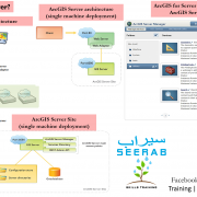
6-Publish map documents as map services using ArcGIS Server—ArcGIS content is brought to life on the web by publishing geographic information as a series of map services. ArcMap provides a simple user experience for publishing your map documents as map services.
7-Share maps, layers, geoprocessing models, and geodatabases with other users—ArcMap includes tools that make it easy to package and share GIS datasets with other users. This includes the ability to share your GIS maps and data using ArcGIS Online.
8-Document your geographic information—A key goal in GIS communities is to describe your geographic information sets to help you document your projects and for more effective search and data sharing. Using the Catalog window, you can document all of your GIS contents. For organizations who use standards-based metadata, you can also document your datasets using the ArcGIS metadata editor.
9-Customize the user experience—ArcMap includes tools for customization, including the ability to write software add-ins to add new functionality, to simplify and streamline the user interface, and to use geoprocessing for task automation.
Learn everyday one new thing … Stay tuned with Seerab : )
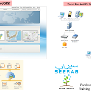
ArcGIS Desktop
Esri