Esri Geodatabase is better then Shape Files
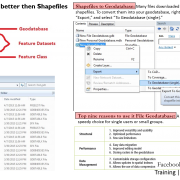
A geodatabase is an alternate way to store #GIS information in one large file, which can contain multiple point, polygon, and/or polyline layers. ESRI is pushing the geodatabase idea, because it is a less “messy” way of organizing data than having multiple shapefiles. in multiple folders. Geodatabases allow users to thematically organize their data and store spatial databases, tables, and raster datasets.
There are two types of single user geodatabases: Personal Geodatabase and File Geodatabase.
Personal geodatabases—All datasets are stored within a Microsoft Access data file, which is limited in size to 2 GB.
A personal geodatabase is a Microsoft Access database that can store, query, and manage both spatial and nonspatial data. Because they are stored in Access databases, personal geodatabases have a maximum size of 2 GB. Additionally, only one person at a time can edit data in a personal geodatabase. Personal geodatabases can also contain domains, use subtypes, and participate in checkout/check-in replication and one-way replicas. You create personal geodatabases in #ArcGIS.
File geodatabases—Stored as folders in a file system. Each dataset is held as a file that can scale up to 1 TB in size. The file geodatabase is recommended over personal geodatabases.
A file geodatabase is a collection of files in a folder on disk that can store, query, and manage both spatial and nonspatial data. A file geodatabase can be used simultaneously by several users, but only one user at a time can edit the same data. Therefore, you can have multiple editors accessing a file geodatabase, but they must be editing different data. The default maximum size of datasets in file geodatabases is 1 TB. The maximum size can be increased to 256 TB for large datasets (usually raster). This is controlled by a configuration keyword. File geodatabases can also contain subtypes and domains and participate in checkout/check-in replication and one-way replicas. You create file geodatabases in ArcGIS.
File geodatabases is preferred storage for Esri ArcGIS and have many benefits including:
1 TB of storage limits of each dataset
Better performance capabilities than Personal Geodatabase
Many users can view data inside the File Geodatabase while the geodatabase is being edited by another user
The geodatabase can be compressed which helps reduce the geodatabases’ size on the disk
Data storage decision is very important … choice and pick wisely … Stay tuned with Seerab : )

