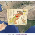
Great Trigonometrical Survey Map
Great Trigonometrical Survey of Indian Subcontinent
Historical Map
The Great Trigonometrical Survey was a project that aimed to survey the entire Indian subcontinent with scientific precision. It was begun in 1802 by the British infantry officer William Lambton, under the auspices of the East India Company. Under the leadership of his successor, George Everest, the project was made the responsibility of the Survey of India. Everest was succeeded by Andrew Scott Waugh, and after 1861, the project was led by James Walker, who oversaw its completion in 1871.
Among the many accomplishments of the Survey were the demarcation of the British territories in India and the measurement of the height of the Himalayan giants: Everest, K2, and Kanchenjunga. The Survey had an enormous scientific impact as well, being responsible for one of the first accurate measurements of a section of an arc of longitude, and for measurements of the geodesic anomaly, which led to the development of the theories of isostasy.
 https://www.seerab.com/wp-content/uploads/2023/09/geology-of-pakistan-1964-map.webp
365
972
Author
https://seerab.com/wp-content/uploads/2017/04/Seerab-Logo-Landscape-Website-300x113.png
Author2023-09-15 10:58:472023-09-15 11:16:47Geology of Pakistan 1964 Map
https://www.seerab.com/wp-content/uploads/2023/09/geology-of-pakistan-1964-map.webp
365
972
Author
https://seerab.com/wp-content/uploads/2017/04/Seerab-Logo-Landscape-Website-300x113.png
Author2023-09-15 10:58:472023-09-15 11:16:47Geology of Pakistan 1964 Map Seerab Maps
https://www.seerab.com/wp-content/uploads/2023/01/great-trigonometrical-survey-map.webp
367
974
Author
https://seerab.com/wp-content/uploads/2017/04/Seerab-Logo-Landscape-Website-300x113.png
Author2023-01-05 23:49:312023-09-15 11:15:52Great Trigonometrical Survey Map
Seerab Maps
https://www.seerab.com/wp-content/uploads/2023/01/great-trigonometrical-survey-map.webp
367
974
Author
https://seerab.com/wp-content/uploads/2017/04/Seerab-Logo-Landscape-Website-300x113.png
Author2023-01-05 23:49:312023-09-15 11:15:52Great Trigonometrical Survey Map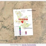 Seerab Maps
 Seerab Maps